Annapurna Circuit and Tilicho Lake Trek-16 Days

Tour Info

Trip code

E-035

Starting Point/ End Point

Kathmadu

Accommodations

Lodge/ Tea House

Max Altitude

5146m

Duration

16 days

country

Trip grade

Easy

Best Season

Spring (March–May) and Autumn (September–November)

Highlights

  • Hike through the varied mountains and forests of the Annapurna Circuit area.
  • Hike to the magnificent Tilicho Lake(4919 m).
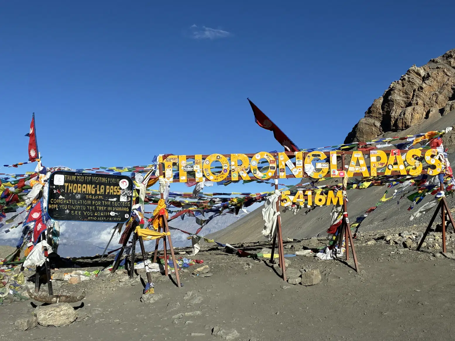
  • Cross the daunting Thorong La Pass (5,416 m).
  • Look out for the panoramic views of the Annapurna mountain range and Dhaulagiri mountain range.
  • Visit the traditional villages of Chame, Pisang, Ngawal, Manang and Muktinath.
  • Explore the distinctiveness of the culture of mountainous communities and their lifestyle.
  • Donate a day to acclimate to the mountains before going to higher elevations in Manang.
  • See the holy temple to Muktinath, one of the pilgrimage sites of the Hindus and Buddhists.
  • Hike through the majestic scenes of the upper Manang and Kali Gandaki Valleys.
  • A beautiful flight from Jomsom to Pokhara, weather permitting.
  • High Mountain, alpine areas, rocky trails and forests are experienced.

Overview

Annapurna Circuit and Tilicho Lake Trek 16 Days is a trek through Annapurna region showcasing the diverse landscape of it. The trail will lead you from the green valleys, forests and traditional villages to the dry and rugged terrain of Manang, Tilicho Lake and Thorong La Pass.

One of the highest lakes in the world, Tilicho Lake 4919 m is a major highlight of the trek. You will also trek past Thorong La Pass (5,416m) to reach Muktinath, a holy pilgrimage spot before going down to Muktinath. En route to the summit it is possible to have views of Annapurna II, III, IV, South of Annapurna, Gangapurna, Tilicho Peak, Dhaulagiri and other Himalayan peaks.

It is also an opportunity to experience the local culture and lifestyle of Manang and Mustang. Along the way, you will find beautiful sacred places such as Muktinath, Buddhist monasteries, traditional villages, and mountain scapes. This is an acclimatisation day to prepare you for the altitude to come that very next day.

Itinerary

Day 1: Arrival in Kathmandu and trek briefing & welcome Dinner

Pick-up and Reach Kathmandu on arrival & check in to the hotel. Once you have checked in and settled in, meetings will take place with the trekking team and a trek briefing. You will be provided with details on the hike, course, lean-to, safety guidelines and training for the trek. Should the time allow, it is also possible to explore the nearby streets of Kathmandu and to also prepare trekking equipment. Sit down for a welcome dinner in the evening and have a good night's rest and enjoy the journey.

  • Maximum Elevation: 1,400 m
  • Travel Distance: As per airport transfer
  • Travel Hours: Approximately 30–60 minutes for airport transfer
  • Accommodation: Hotel in Kathmandu
  • Meals: Welcome dinner
Day 2: Drive from Kathmandu to Dharapani

Once breakfast, start off the scenic drive from Kathmandu to Dharapani. Your ride will follow smooth and well-paved roads until Besisahar, passing through rivers, terraced farmlands, forests, and rustic hamlets. After Besisahar, the road gradually ascends and becomes bumpy and mostly off-road as you travel deeper into the mountain region. The entire way, you will be along the Marsyangdi River, watching how things start to shift from what was once the hustle bustle of a city to the peace and tranquility of a mountain environment. Pass through Besisahar and head towards Dharapani where you'll spend the night. You've arrived in Dharapani, which is the starting point of the major trek towards the Annapurna Circuit. 

  • Maximum Elevation: Around 1,960 m
  • Travel Distance: Approximately 200–215 km by road
  • Travel Hours: Around 8–9 hours
  • Accommodation: Teahouse/Lodge
  • Meals: Breakfast and dinner
Day 3: Trek to Chame

After spending your first day in Dharapani, head to Chame, the headquarters of Manang District and a relatively larger mountain town due to the presence of various government offices and facilities. The trail passes through pine and fir forests, small mountain settlements, and sections of the Marsyangdi Valley. En route, you will pass through villages like Bagarchhap, Danaque, and Timang. After Timang, at some points along the trail, you can also enjoy views of Manaslu, adding another spectacular Himalayan panorama to the journey. As you continue towards Chame, the mountain scenery becomes increasingly impressive, with views of Lamjung Himal and Annapurna II along the way. Upon reaching Chame, settle into your tea house and enjoy the evening in this lively mountain town. 

  • Maximum Elevation: Around 2,670 m
  • Travel Distance: Approximately 14 km
  • Travel Hours: Around 5–6 hours
  • Accommodation: Teahouse/Lodge
  • Meals: Breakfast, lunch and dinner
Day 4: Trek to Pisang

Today, head down the Marsyangdi Valley towards Pisang. The trail leads through pine and fir woodlands and along the river, surrounded by an impressive mountain landscape. You will pass through Brathang, where you can see one of the largest apple farms in the region, before continuing towards the remarkable Paungda Danda rock face, one of the most striking natural formations along this section of the Annapurna Circuit. The valley opens further as you continue, offering views of Annapurna II, Pisang Peak, and other surrounding mountains. Head to Pisang and take it easy as you relax and experience the peaceful village life, if time permits. 

  • Maximum Elevation: Around 3,200–3,300 m
  • Travel Distance: Approximately 14 km
  • Travel Hours: Around 5–6 hours
  • Accommodation: Teahouse/Lodge
  • Meals: Breakfast, lunch and dinner
Day 5: Trek to Ngawal

On this day, you will enjoy a scenic trek from Pisang to Ngawal, passing through the traditional villages of Ghyaru and Ngawal. The trek from Pisang to Ngawal takes around 4 to 5 hours, making it a suitable day for gradual acclimatization. As you ascend, you can enjoy magnificent views of Annapurna II, Annapurna III, Annapurna IV, Gangapurna, Pisang Peak, and the surrounding Manang Valley. After reaching Ngawal, you will have lunch and then take a short uphill hike to a Buddhist stupa, from where you can enjoy beautiful views of the surrounding mountains and Ngawal village. The dry mountain landscapes and wide valley views make this one of the most scenic sections of the Annapurna Circuit. After exploring the area, spend a peaceful evening in the ancient Himalayan village of Ngawal. 

  • Maximum Elevation: Around 3,660 m
  • Travel Distance: Approximately 10–12 km
  • Travel Hours: Around 4–5 hours
  • Accommodation: Teahouse/Lodge
  • Meals: Breakfast, lunch and dinner
Day 6: Trek to Manang

Today's trail takes you through the stunning upper Manang Valley before reaching the mountain village of Manang. The trail leads through the small villages such as Mungji in the direction to Manang. As one goes further in the Himalayan rain-shadow area the land gets drier and drier. You get to the view of the Annapurna III, Gangapurna, and Tilicho Peak etc. along the way. Manang is worth stopping at as it is a good break and time to acclimatize for the high elevations to come.

  • Maximum Elevation: Around 3,540 m
  • Travel Distance: Approximately 10 km
  • Travel Hours: Around 4–5 hours
  • Accommodation: Teahouse/Lodge
  • Meals: Breakfast, lunch and dinner
Day 7: Acclimatisation Day: a little short hike uphill and explore Manang village

It is an important acclimatization day in Manang today, allowing your body to adjust to the higher altitude before continuing towards Thorong La Pass and Tilicho Lake. After breakfast, hike uphill to a viewpoint for beautiful views of Manang village and the surrounding mountains. You will also hike towards Gangapurna Lake, where you can enjoy stunning views of the turquoise lake and Gangapurna Mountain. The gradual hike provides a good opportunity to gain some elevation while acclimatizing. After the hike, return to Manang and spend some time exploring the village. You can visit a local monastery, walk through the traditional settlements, or simply relax and enjoy the mountain scenery. Get plenty of rest and stay hydrated to prepare for the higher elevations ahead. 

  • Maximum Elevation: Around 3,900–4,100 m during the acclimatization hike
  • Travel Distance: Approximately 5–8 km, depending on the hiking route
  • Travel Hours: Around 3–5 hours of hiking
  • Accommodation: Teahouse/Lodge
  • Meals: Breakfast, lunch and dinner
Day 8: Trek to Tilicho Base Camp

After breakfast, you leave Manang and begin the trek towards Tilicho Base Camp. From this point, the path winds through the valley of Marsyangdi, then moves towards Khangsar Village, the old village built with stone houses and charmed by the beauty of the hills. The terrain becomes more rugged and up the higher alpine area from Khangsar.Along the way, you will pass through rocky sections, steep slopes, and areas prone to landslides, making this part of the trek more challenging. On the higher plateau, the undergrowth is sparse and the vistas of other peaks are increasingly grand. Carefully head towards the Tilicho Base Camp where you will rest at your lodge. Sleeping will be a key factor in getting a lot of sleep as you will be up and about early the next morning to make it to the Tilicho Lake (TMS).

  • Maximum Elevation: Around 4,150 m
  • Travel Distance: Approximately 12–15 km
  • Travel Hours: Around 6–7 hours
  • Accommodation: Teahouse/Lodge
  • Meals: Breakfast, lunch and dinner
Day 9: Early morning Visit to Tilicho Lake and Trek to Siri Kharka

Early morning start and a challenging trek to the lake of the skull at Tilicho, at a height of 4,919 m. The trail ascents gradually from base camp through dry, rocky and high elevation terrain. As one approaches the lake the scenery opens up with marvelous views of the mountains and deep valleys below. Once at Tilicho Lake take a moment to relax and enjoy the tranquil of this location before starting down to the next lake. The return leg of the journey is the return trip to the lower part of the trip. Continue trekking towards Siri Kharka, where you will spend the night. This is an intense day, pace yourself and stay hydrated!

  • Maximum Elevation: 4,919 m
  • Travel Distance: Approximately 14–16 km
  • Travel Hours: Around 6–8 hours
  • Accommodation: Teahouse/Lodge
  • Meals: Breakfast, lunch and dinner
Day 10: Trek to Yak Kharka

After breakfast you resume the main route on the Annapurna Circuit. The route will cross the arid, open terrain of the Thorong Khola Valley. There are fewer trees at this elevation and the areas are characterized by rocky slopes, broad valleys and bare mountain land compared to those lower down. Bear right (up) through the high altitude terrain, gradually approaching Yak Kharka. Yaks and other animals of the Himalayas may be grazing on the hillsides. The trail resumes its ascent on the approach to Yak Kharka. Upon arriving, you will be supremely welcomed into your teahouse and then you will get ready for the remainder of the trek towards Thorong Phedi.

  • Maximum Elevation: Around 4,050 m
  • Travel Distance: Approximately 10 km
  • Travel Hours: Around 5–6 hours
  • Accommodation: Teahouse/Lodge
  • Meals: Breakfast, lunch and dinner
Day 11: Trek to Thorong Phedi

Today, you will hike from Yak Kharka to Thorong Phedi, the main overnight stop before crossing Thorong La Pass. The trail follows the Thorong Khola and gradually ascends through increasingly rugged and desolate terrain. Along the way, you will also cross the rocky landslide section near Thorong Phedi, adding to the rugged character of this part of the trail. Although the hiking distance is shorter than on some previous days, the higher elevation makes the trek physically demanding. Walk at your own pace, take regular breaks, and drink plenty of water. Enjoy the surrounding mountain scenery and imposing views of the Annapurna landscape as you make your way to Thorong Phedi. Upon arrival, relax at your teahouse and prepare your gear, water, and other essentials for the early start and challenging ascent to Thorong La Pass the following morning. 

  • Maximum Elevation: Around 4,450 m
  • Travel Distance: Approximately 7–8 km
  • Travel Hours: Around 4–5 hours
  • Accommodation: Teahouse/Lodge
  • Meals: Breakfast, lunch and dinner
Day 12: Trek to Muktinath via Thorongla Pass (5,416m)

The most difficult day of the trek is today as you cross Thorong La Pass at 5,416 m, the highest point of the Annapurna Circuit. Start early in the morning when the trail is usually quieter and the weather is more favorable. The trail winds through rocky and open terrain, making the climb physically demanding due to the high altitude. Take slow, steady steps, breathe comfortably, and take regular breaks as needed. During the ascent, you can enjoy views of Thorong Peak and the surrounding Himalayan mountains. Upon reaching Thorong La Pass, take some time to appreciate the spectacular mountain scenery before beginning the long descent. From the pass, the trail descends towards Muktinath. As you cross into Mustang District, you will notice a dramatic change in the landscape, with the dry and rugged terrain of the Mustang region replacing the greener landscapes of the lower Annapurna area. From Muktinath, you can also enjoy views towards the magnificent Dhaulagiri range. Muktinath is an important pilgrimage site for both Hindus and Buddhists and is one of the major cultural highlights of the journey. 

  • Maximum Elevation: 5,416 m at Thorong La Pass
  • Travel Distance: Approximately 15–16 km
  • Travel Hours: Around 7–9 hours
  • Accommodation: Teahouse/Lodge
  • Meals: Breakfast, lunch and dinner
Day 13: Trek to Jomsom

Post breakfast, head down the Kali Gandaki Valley towards Jomsom, where the landscape becomes increasingly dry and rugged. The trail passes through traditional villages, barren hills, and wide open valleys, offering a striking contrast to the greener landscapes experienced earlier on the Annapurna Circuit. En route, you can enjoy views of Nilgiri, Dhaulagiri, and surrounding peaks in clear weather. Jomsom is the headquarters of Mustang District and an important administrative, commercial, and transport hub of the region. The area is also known for its strong afternoon winds, with the valley generally becoming windy after around 10:00 to 11:00 AM. The trail also provides opportunities to experience the traditional lifestyle and distinctive architecture of the Mustang region. Upon reaching Jomsom, check in at your lodge and rest in preparation for your flight to Pokhara the following morning. 

  • Maximum Elevation: Around 3,800 m
  • Travel Distance: Approximately 18 km
  • Travel Hours: Around 5–6 hours
  • Accommodation: Teahouse/Lodge
  • Meals: Breakfast, lunch and dinner
Day 14: Early morning flight to Pokhara

Get up early and get ready for your flight from Jomsom to Pokhara. This is a brief and scenic mountain flight over the Kali Gandaki Valley. Flights are scheduled early in the morning because the Jomsom area is generally windy after around 10:00 to 11:00 AM, and the strong winds can make afternoon flights difficult. Flights may also be delayed, rescheduled, or cancelled if weather conditions are unfavorable. Upon arrival in Pokhara, transfer to your hotel and relax after completing the trek. The afternoon is free to rest at the hotel, stroll around Lakeside, visit Phewa Lake, or explore some of Pokhara's popular attractions. 

  • Maximum Elevation: Around 2,700 m at Jomsom
  • Travel Distance: Approximately 60–70 km by air route
  • Travel Hours: Around 20–30 minutes flight time
  • Accommodation: Hotel in Pokhara
  • Meals: Breakfast
Day 15: Drive back to Kathmandu by tourist Bus

Return to Kathmandu from Pokhara after breakfast. The road is the main one running up the hills and offers the last chance to see the landscapes ruggedly changing in Nepal. You will cross rivers, green hills, terraced farms and small towns and traditional villages along the way. The 
road passes through poths and ditches to trace part of the course of the Trishuli River and provides scenic views along the route. This takes about a few hours typically depending on traffic, conditions and the type of car being used. In Kathmandu, after you make your hotel reservation, hang out and unwind a bit. As the final night of the journey, you can use it for shopping, exploring the surrounding area or simply rest after days of trekking before your evacuation to the international area the next day.

  • Maximum Elevation: Around 1,400 m
  • Travel Distance: Approximately 200 km by road
  • Travel Hours: Around 6–8 hours
  • Accommodation: Hotel in Kathmandu
  • Meals: Breakfast
Day 16: Final Departure

After breakfast, check out from your hotel and prepare for your departure from Nepal. If this is the case, you might want to spend a little extra time in Kathmandu city prior to your journey to Tribhuvan International Airport. Please bring along your passport, travel documents, flight information, and carry your belongings with you before you depart from the hotel. You will be picked up from the airport to return to your helicopter flights, which will be at the Intl Terminal. You have trekked one of the most interesting and varied routes in Nepal, the Annapurna Circuit and Tilicho Lake Trek 16 Days now finished. The trip includes the experience of the mountain scenery, the traditional villages of the Himalayas, the landscapes at high altitudes, Tilicho Lake, Thorong La Pass and the cultural heritage of Manang or Mustang.

  • Maximum Elevation: Around 1,400 m
  • Travel Distance: As per airport transfer
  • Travel Hours: Approximately 30–60 minutes for airport transfer
  • Accommodation: Not included
  • Meals: Breakfast

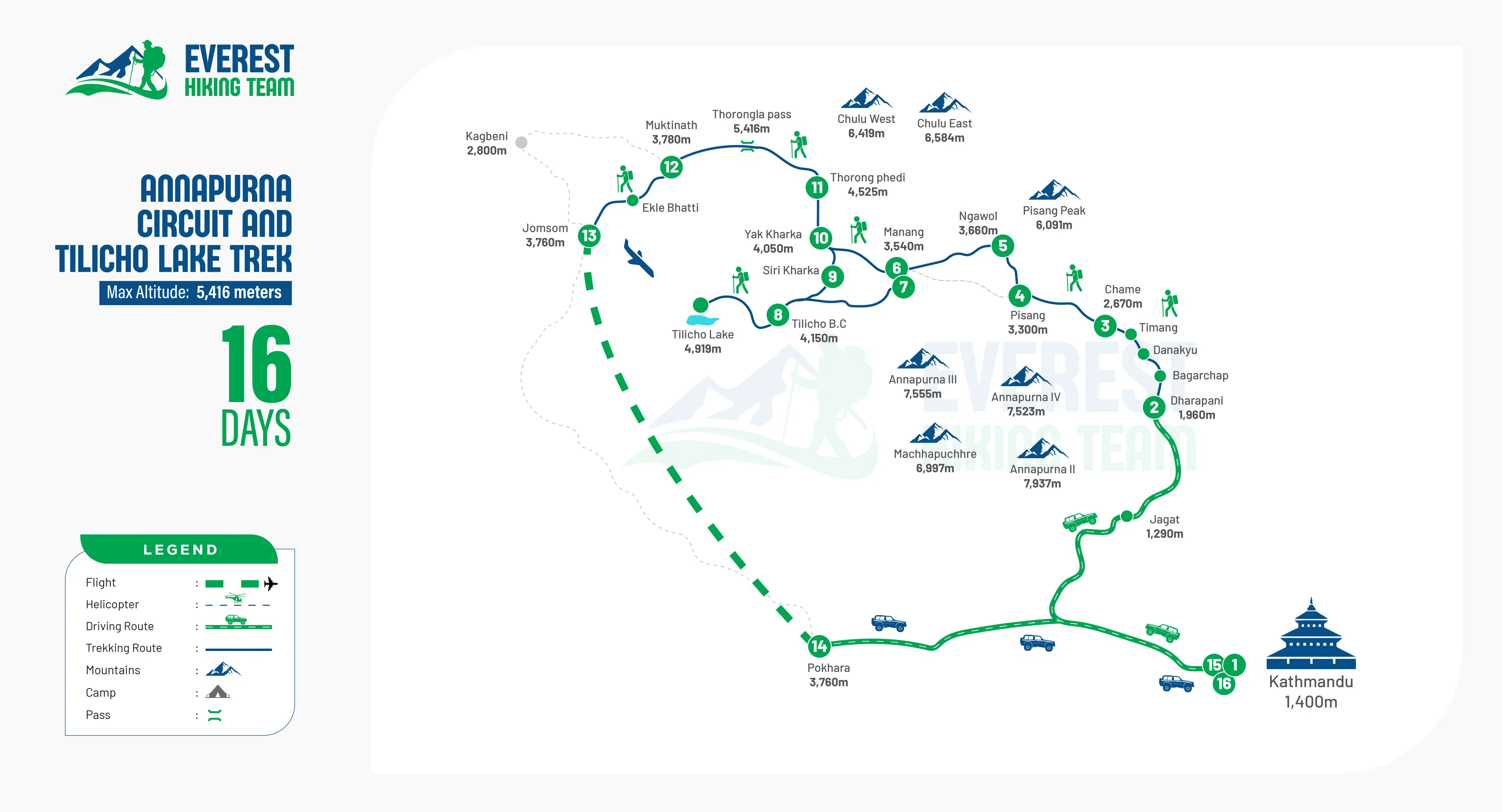
Trek Route

Annapurna Circuit and Tilicho Lake Trek-16 Days route image

What's included

  • Airport pick-up and drop-off services by private vehicle.
  • welcome Dinner.
  • Kathmandu-Besisahar by private vahicle and Besisahar-Dharapani by shared jeep. 
  • 2 nights accommodation in kathmandu .
  • 1 nights accommodation in pokhara.
  • During the trek: 3 meals (breakfast, lunch and dinner with the 3 cup of tea/coffee per day).
  • Accommodation in teahouses/lodges, During the trekking.
  • Annapurna Card for Conservational Permits (ACAP) and Trekkers' Information Management System (TIMS) card.
  • English speaking, experienced, government licensed Ministry of Tourism trained trekking guide, breakfast through to accommodation, guide's salary, and insurance.
  • One porter for two trekkers .
  • One assistant trekking guide for groups over 8 people, during the voyage (including meals, accommodation, salary and insurance).
  • An oxygen level check and monitor measuring oxygen saturation, pulse and heart rate that tracks twice each day, while the hiker is on trek.
  • trekking map 

What's excluded

  • Lunch & Dinner in Kathmandu and Pokhara.
  • Tips for Guide,porter and Driver.
  • Entry Visa fee to Nepal. The fees for Visa on Arrival are USD 30 for 15, USD 50 for 30 and USD 125 for 90 days.
  • Travel via air and international travel costs..
  • Compact personal travel & medical traveling.
  • Money for personal needs for purchasing.
  • mineral water and other purchased beverages – alcoholic or not – eaten during the trek.
  • Additional food, snack items, desserts, chocolates, cakes, pies and other individual food items purchased.
  • Hot showers and charging batteries at teahouses.

Packing List

The Annapurna Circuit and Tilicho Lake Trek traverses various altitudes and scenery  through lower valleys within the mountains up to the high valleys near the Thorong La Pass and Tilicho Lake. Clothing and trekking equipment choices will ensure comfort in varying weather and temperatures. Avoid buying too many things – pack light and only those items you will be using on the walk. Due to seasonality, individual needs and package contents you may change this list accordingly.

Clothing

  • Warm down jacket
  • Waterproof and windproof jacket
  • Fleece jacket or warm mid-layer
  • 2–3 long-sleeved trekking shirts
  • 2 pairs of comfortable trekking pants
  • Warm thermal base-layer top and bottom
  • Waterproof pants
  • 4–5 pairs of underwear
  • 3–4 pairs of trekking socks
  • 1–2 pairs of warm wool socks
  • Warm hat or beanie
  • Sun hat or cap
  • Warm gloves
  • Neck gaiter, scarf, or buff

Footwear

  • Comfortable waterproof trekking boots with good ankle support
  • Lightweight shoes or sandals for evenings
  • Extra shoelaces
  • Gaiters, especially useful in snow, mud, or dusty sections

Trekking Gear

  • Small daypack
  • Duffel bag or trekking backpack
  • Warm sleeping bag suitable for high-altitude conditions
  • Trekking poles
  • Reusable water bottles or hydration bladder
  • Headlamp with extra batteries
  • Sunglasses with UV protection
  • Backpack rain cover
  • Dry bags or waterproof bags
  • Small luggage lock

Toiletries and Personal Care

  • Toothbrush and toothpaste
  • Toilet paper
  • Wet wipes
  • Hand sanitizer
  • Sunscreen
  • Lip balm with SPF
  • Moisturizer
  • Small quick-drying towel
  • Soap and shampoo
  • Personal hygiene products

First-Aid and Personal Medicine

  • Personal prescription medicines
  • Basic first-aid supplies
  • Blister plasters
  • Pain relief medicine
  • Medicine for common stomach problems
  • Oral rehydration salts
  • Bandages and antiseptic wipes
  • Altitude-related medicine, if recommended by a doctor

Important Documents and Money

  • Passport
  • Copies of your passport and visa
  • Travel insurance documents
  • Insurance covering high-altitude trekking and emergency evacuation
  • Passport-sized photos
  • Emergency contact details
  • Nepalese rupees for personal expenses

Electronics

  • Mobile phone
  • Camera
  • Power bank
  • Charging cables
  • Universal travel adapter
  • Extra camera batteries or memory cards

Optional Items

  • Energy bars, nuts, or other light snacks
  • Earplugs
  • Small book or journal
  • Playing cards
  • Notebook and pen
  • Reusable cup
  • Small binoculars
  • Small personal first-aid pouch
  • Trekking towel

Frequently Asked Questions

How difficult is the Annapurna Circuit and Tilicho Lake Trek?

The Annapurar circuit and tilicho lake trek is of moderate to hard level due to the hours of trekking, the high altitude as well as crossing thorong-la pass (5416 m). There are also hard and rocky parts of a walk to get to the Tilicho Lake. Taking steps to be in good physical condition and acclimated can make the walk a little easier.

What is the highest altitude reached during the trek?

The peak of this trek is Thorong La Pass (5,416m). A key highlight at high altitude is the famous theoretical Lake at an elevation of about 4919m, namely the Tilicho Lake. At these heights, it is important to acclimate and take one's time when walking.

Is an acclimatization day included in the trek?

Yes, the itinerary includes an acclimatization day in Manang. A quick trek around the Manang Valley is possible, or if you prefer to visit one of the areas vantage points without getting into the boat, head to one of the lakes and then make back to Manang. This will help your body acclimate to the rising elevation before heading to a higher elevation.

What permits are required for the Annapurna Circuit and Tilicho Lake Trek?

In general, the trek needs to be registered with Annapurna Conservation Area Permit (ACAP), and a Trekkers' Information Management System (TIMS) card. These permits are necessary for hiking in the Annapurna region and should be booked in advance.

When is the best time to do the Annapurna Circuit and Tilicho Lake Trek?

The ideal seasons are spring (March to May) and autumn (September to November) as the weather tends to be more settled and mountain views are much clearer. November and October especially are popular months to visit Annapurna. Other seasons are also good for trekking but some trails could be steeper because of the weather, snow, rain and trail conditions.

Is the Jomsom to Pokhara flight guaranteed?

No. The Jomsom–Pokhara is weather-sensitive. A flight program is generally offered during the morning hours, however delays or cancellations may be made due to strong winds, poor visibility or some unfavorable condition. Maintain flexibility, in case of any change in flights.

User Review